 ANBG Archive Document, 1979
Published in: Museum Education Association of Australia, Report of Perth Conference, 24-30 August, 1979
TWO BOTANIC GARDEN TRAILS
by Murray Fagg, Education officer,
National Botanic Gardens, Canberra
Because the people involved with education at various institutions seldom have the background in matters relating to timber work and materials, I thought it might be an advantage to outline step by step the formation and development of the two trails in the National Botanic Gardens before discussing their use.
The two trails under discussion represent different initial designs, the Nature Trail is a path through what was originally a piece of untouched Bushland within the Botanic Gardens, while the Aboriginal Trail uses the existing paths through the older established sections of the Gardens.
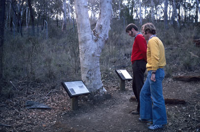 The Nature Trail at the top of the Gardens (David Young, Mark Clements), July 1978 |
Nature Trail
The Nature Trail, the earlier of the two, was the brain-child of our Rangers who recognised a need to introduce aspects of the natural environment to children in order to achieve a better understanding of the total Botanic Gardens concept. The curator agreed with the idea proposed, but as money was not available for tradesmen, the Rangers went it alone cutting the path, building a rude timber bridge from local timber ![]() and organising the moving of a complete termite colony in consultation with entomologists from CSIRO
and organising the moving of a complete termite colony in consultation with entomologists from CSIRO ![]()
![]() .
.
The subject for discussion at the points along the trail were selected by the Rangers and the texts for the illustrated signs were written by staff with biological training.
Several materials were examined as possibilities for signs. Routed wooden signs as used in other parts of the gardens would have had to be very large to accommodate all the information required. Photo-metal aluminium signs, as produced by Altone Pty. Limited, were decided upon as they could also reproduce black and white photographs. The plates were each 25 cm x 30 cm (10" x 12").
The artwork for the signs was produced by the Garden staff, the printing was sent out to a private typist and typed on an IBM Composer machine. The printing was enlarged by photographing the original on Kodalith film and printed to the required size in our darkroom. Printing and artwork, together with any black and white photographs were pasted up to finished size and sent to Altone.
A system of mounting the signs had to fit in with the existing rough finished stained wood used in other parts of the Gardens. It has to be fairly tough to withstand public attention in an area quite remote from supervision. The posts were Perma-pine' treated logs, with 35 cm x 5 cm (l4" x 2") rough, sawn oregon tops, backed with 5 cm x 5 cm (2"ox 2") cleats to prevent warping. The 15 cm (6") diameter logs were cut at 45 degrees, tops were bolted on and the head counter-sunk on the top surface while the nut was inset into the log, making it impossible remove without a tube-spanner (not commonly carried by the public).
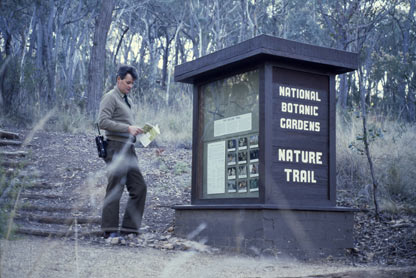 Ranger Kurt Thaler at the 'information box', ANBG Nature Trail, August 1979 |
The photo aluminium plates were glued to the timber with contact cement and a small escutcheon pin nailed through a drilled hole in each corner to provide a visible form of attachment. Three structures on the trail required the services of carpenters, the steps leading into and out of the gully ![]() , and the box at the start of the trail.
, and the box at the start of the trail.
This information box served several purposes. It hides large water-mains and stop-cock, sunk into the ground at that spot: the box was built on top of this. It provides storage at the trail for spare leaflets, a few maintenance implements etc., and it has a map of the trail plus photographs and information, behind glass, in a south-facing direction, to avoid the direct sun.
Photographs of plants, or other items of natural history, are displayed on the board in season, 12 photos in all ![]() . They are glued on with a caption, to pine-board blocks and attached to hooks on the display board. They are changed each week, and those not in use are stored in the box.The photos are normal colour post-card prints from Kodacolour print film and they are now in their 3rd year without a great deal of fading.
. They are glued on with a caption, to pine-board blocks and attached to hooks on the display board. They are changed each week, and those not in use are stored in the box.The photos are normal colour post-card prints from Kodacolour print film and they are now in their 3rd year without a great deal of fading.
Two types of printed material are given out for the trail users. The printed leaflet is a general background to the trail and is available from our Display enquiry desk and at the trail box. A second sheet, changed seasonally, is available from the box or given out by the Rangers and introduces this trail in that particular season. It also gives a list of plants which will enable most members of the public to identify each flower growing on the trail. This does not, of course, cover the and related plants not usually accepted as 'flowers' by the general public.
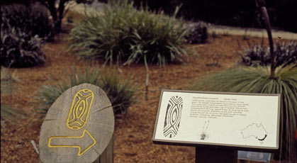 Trail route marker and photo-aluminium label, August 1979 |
Aboriginal Trail
The Aboriginal Trail was initiated in quite a different way. In 1975, there was a Science Exhibition in Canberra - Australia '75, and the Botanic Gardens arranged tours on the subject of Aboriginal plant use to coincide with a display on that theme. Public response was good and the idea of establishing the tour as a trail was followed up by our Rangers.
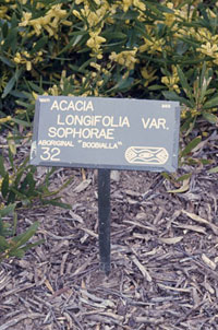
The selection of plants to be discussed on the trai was based on a wide range of source references gathered together during educational display preparation. Initially, 57 plants were used and a duplicated set of handout sheets was given to visitors, the plants were distinguished by engraving a shield motif on the normal Gardens formica label, and adding an engraved trail number ![]() .
.
During the following 8 months we actively sought feed-back from selected visitors and asked people from the University Prehistory and Anthropology Departments as well as the Department of Aboriginal Affairs, to make comments on their sets of printed notes and return them to us. The route and information was reassessed at this time, alterations were made to the printed notes, and the number of species was reduced to 44 to shorten the time for the walk.
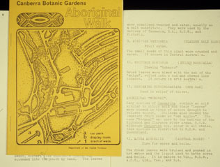 The second hand-out guide, May 1977 |
A second booklet was produced using a cheap duplicating process and the numbers were altered on labels to allow for the reduced number of species. The trail was advertised more widely at this time. The trail proved popular with the general public and school groups, led by our Rangers, and it was decided to print a leaflet to match the style of the Nature Trail leaflet.
One of our staff produced a series of small illustrations for each plant on the trail and a selection of these were used in the leaflet, together with a numbered route map. This was in use from May, 1977 until January, 1979, but during this time we found several problems.
The first problem was a major changing of paths in one area transversed by the trail, and the second and more important problem was due to our numbered plants in sequence along the route. Plants died, and despite there being other specimens on the trail, the fixed number sequence made this very confusing, and at some times a plant may be completely absent awaiting repropagation, while the public searched in vain for the missing number.
The leaflet was redesigned and reprinted, using no number sequence, listing the plants in alphabetical order and redrawing the map. The numbers were removed from the engraved labels leaving only the shield motif.
We then found people getting lost and missing many of the plants by overlooking the labels as the map no longer indicated where each plant should be. It was decided that the labels must be more distinctive and the trail signposted at every path intersection. Photometal signs were decided upon for labels and angle topped treated pine logs for the directional signs ![]() .
.
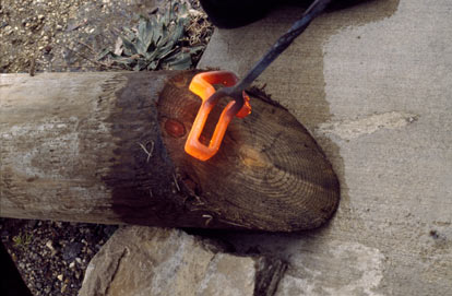 Branding the arrow with a red-hot cattle branding iron, August 1979 |
Because the new labels would be scattered among existing Botanic Gardens labels, we designed them the same size 15 cm x 30 cm (6" x 12"), made of photometal with narrow border of dark anodized aluminium with a 2.5 cm (1") formwork plywood backing , on l0 cm x 10 cm (4" x 4") lengths of Australian hardwood timber and mounted at 45 degrees ![]() .
.
The directional arrow and motif were branded onto the angle-topped logs with cattle brands which we had made by a blacksmith. The branding was done onto damp logs to prevent excessive charing. The branded part was cleaned up with a wire brush to remove the ash, painted yellow to distinguish it from our other walks, then sanded with an orbital- sander.
Trail usage - Firstly, the Nature Trail
Each year, the Rangers conduct about 30 school groups over the Nature Trail, each group averaging about 20 students The use by the general public is restricted due to its distance from the main public access to the Gardens (it takes about 20 minutes to walk to the start of the trail from the car park), but during the first 9 months, 10,000 leaflets were either requested from our enquiry desk, or taken from the box at the trail, and the same number were used the following year.
We try to restrict school class size to about 20 - 30 but of course this is not always possible. It is found that most teacher of school groups, surprisingly, do not want the students to have the general Nature Trail Guide Leaflets, as their essays and reports become a direct copy; perhaps it is only the leaflet that keeps the teachers one step ahead of the students !
What do they see on the Nature Trail?
After leaving the information box the first 'station' looks at the general vegetation, followed by an explanation of Exocarpos cupressiformis, the Native Cherry, with its edible fruit and parasitic habit. A self-sown exotic pine tree opens up the subject of invasion of plant into our bushland, and a natural hybrid between the two dominant eucalypt can bring in as much genetics as a teacher wishes to parsue.
The Rangers always leave a few pieces of termite mound from elsewhere to hand around to students at the mound site.
A few rough log seats provide an assembly point for a general talk at the only spot where students are not strung out along a narrow path. Photographs of a bark canoe and bark hut illustrate the use of this local material but we had problems with the initial design of our bark shelter and it is pre sently being rebuilt.
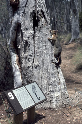 Brush-tailed Possum station, sign, possum, trap, December 1979 |
A tree, presumed to have been struck by lightening, is an interesting talking that point, but it is the Brush Tail Possum, hopefully trapped the night before that really excites the children. It is kept in a box made from a hollow log, and released during a tour.
The scar or lack of it along the line of underground cables to the original Black Mountain Tower introduces environmental disturbances by man.
The 'Bull Ant' station has not been very successful as they are seldom seen, while the honey-bees have vacated their hollow branch a couple of times and have had to be reintroduced. Both of these point to a major problem which we would not repeat, the numbering of the stations making it hard to rearrange the site if anything changes.
The Scribbly Gum, Eucalyptus rossi, is always of interest, and the sign has a photo of the moth whose larvae makes the scribbles.
We are fortunate in having a steep, eroded gully to illustrate the soil profile and recent geological events. Steep steps lead into the gully and stepping stones provide the path when water occasionally trickles along its length. A sign explains the numerous mosses and lichens and a pool caused by the road embankment has a small marsh area. This is kept damp artificially during dry spells. Steps then lead out of the gully at the end of the trail.
What problems have emerged over three years use? Very few in fact. Vandalism is confined to a couple of label dents The vegetation has hardly suffered at all. I've mentioned the problems caused by numbered stations, which makes it hard to add new points of interest or eliminate problem sites. The distance from the Gardens entrance can be a problem when school groups have only a short period for the tour, but the walk also serves as a good quietening-down period after a long bus trip.
The Aboriginal Trail Use
This is much harder to speak about as the most recent modifications were only carried out in the weeks prior to my coming to Perth. I hope that I have outlined the problems we have had and how we overcome them.
One problem that I should mention involved the inclusion on the trail of an aboriginal narcotic plant, Duboisia, commonly known by the Aboriginal name of 'pituri'.
We found our plant being progressively pruned. Some students eventually finished up in hospital after smoking it (the leaflet definitely said it was chewed !) Even after eliminating it from the leaflet, we found one plant dug up. We finally had to blank out the labels throughout the Gardens.
Because of the number of plants involved, I will not try to speak about each, the details on the labels are the same as those in the leaflet, they are, in fact, enlargements of the leaflet typesetting.
The number of school groups taken over this trail last year was about 50, each group averaging about 15. In contrast with the Nature Trail, teachers usually like each student to take one leaflet. The number of leaflets given to groups, or requested from our enquiry desk since May 1977, is 20,000. We hope that with the present changes to the trail, a publicity campaign this spring will make far more people aware of the trail.
![Director of National Parks [logo]](../../../images/dnp_90px.gif)


