The Plant Records Unit
Label Policy | Propagation Numbers | Thematic Plan of Sections | Living Collection Profile | Search for plant | Map showing Sections
The Australian National Botanic Garden has developed its collections predominantly from 'wild sourced' propagation material, which is scientifically documented in situ. This includes taking a pressed herbarium voucher specimen for each batch of material collected for propagation. The voucher specimens are identified in the Australian National Herbarium and the collection data, with verified identity, are held on the IBIS database linked by common accession identifier to the living and herbarium specimens and any photographs taken in the field or later in cultivation. These integrated living, herbarium and data collections are maintained as a resource for the scientific study of the Australian flora.
The Plant Records Unit maintains the database of information on the status of the living collections after they are planted in the Gardens. The database includes the location in the Gardens, the numbers of plants, propagation history and accession number. Links to the herbarium vouchers ensure verified identifications and subsequent name changes on labels when botanical research results in new botanical names. This information is used to facilitate curation of, and research on, the living collections. Accurate labeling of plants assists in the preparation of interpretive material for visitors.
For management purposes the Gardens is divided into 273 Sections (garden beds), each refered to by a unique number. Sections were initially given numbers in the order that they were developed, but over time, with re-development of various parts of the Gardens and re-allocation of section numbers they now appear almost randomly located.
The content or planting-theme for each Section of the Gardens is set out in the Thematic Plan.
The Plant Records Unit attempts to 'stocktake' each Section of the Gardens about once every 2-3 years.
The publicly accessable records, searchable on the web, indicate which Section/s a plant is growing in. [Search] Maps showing Section Numbers are available from the Visitor Centre or the web.
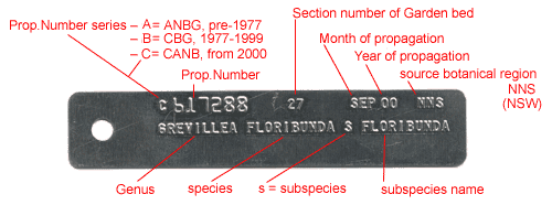
The allocation of Propagation Identification numbers (Prop_IDs) to plants within the ANBG is complex, and has changed during the Gardens' history with changes to computer technology.
Major tasks undertaken within the Plant Records Unit include:
- Stocktake:
- record the location and number of plants
- map gardens sections to position each plant within a section boundary
- tag plants with their unique accession number (propagation number), scientific name and garden section number
- Update database when plants die or are moved
- Update database and plant tags when plant names change
- Labelling of plants
- Maintenance of ANBG maps with section boundaries and numbers
- Collection of voucher specimens for identification by herbarium staff
- Liaise with ANBG Visitor Services staff developing interpretive material
- Liaise with ANBG Collections officer to develop the living collections
The Gardens label system
Aluminium tags - computer generated embossed tags, fixed to the plant or to a stake at its base, recording plant name and propagation number associated with stocktake. The dimensions of the tags are 115mm x 22mm, about 0.5mm thick.
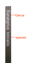
Stake labels - the oldest labeling system in the Gardens, showing the name of the plant, very simple, but must be read vertically.
Dimensions 400mm x 25mm, 3mm thick.
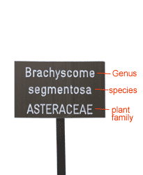
Rockery labels - designed for smaller plants in garden beds where a sea of stake labels would look out of place. They include the plant name and family.
Dimensions 100mm x 65mm, 3mm thick.
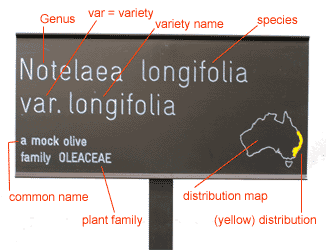
Large labels - larger, with space for plant name, common name, family and a distribution map.
Dimensions 300mm x 150mm, 3mm thick.
Stake label |
Rockery label |
Large label |
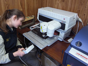 Computer controlled label engraving machine (click to enlarge) |
See Plant Label Policy for the ANBG for more details.
See Propagation Number Explanation for more details.
![Director of National Parks [logo]](../../../images/dnp_90px.gif)


